Don Paul: The consequences of a record-warm Lake Erie

All five Great Lakes are headed toward record warmth this summer, including the biggest and coldest one, Lake Superior.

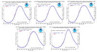
In a map of satellite and buoy-derived surface temperatures (contours are in Celsius), Lake Erie has enhanced its normal status as the warmest of the lakes.
The warmest temperatures are at the western end of the lake, mainly because it’s the shallowest portion of the shallowest Great Lake. The 26 Celsius contour shows that end of the lake is already at about 79 degrees. Warmest lake readings usually occur late in July and can linger well into August, depending on the overall weather pattern. The contours at our end of the lake are not quite as warm, but they are running well above average. The Buffalo Water Treatment Plant lake temp is at 76, with an average of 72 for the date, and an average highest seasonal reading of just 73.
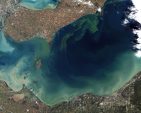
One of the most serious of negative consequences to such warmth is an increase in the likelihood of toxic algae growth. Not all algae is a toxic threat, but the most common type is a cyanobacteria that releases a toxin capable of causing drinking water problems at the western end of the lake. The volume of such algae at the eastern end of the lake is considerably less. The shallower western end also receives more agricultural runoff from fertilizer and manure, providing much more nutrient material for the algae, both toxic and nontoxic.

There are factors other than warmth in play. The amount of rainfall and the runoff it produces is key. This year, algae forecasts are for moderate blooms at the western end despite the near record warmth, and not as serious as the 2019 blooms.
The good news for our end of the lake is a somewhat reduced hazard at the western end – where the most prolific toxic blooms occur – makes the volume of toxic blooms in the eastern waters likely to be lower as well, despite all the heat that we’ve had and that is still to come. There is even a National Weather Service/NWS 96-hour model for bloom locations, which are currently confined to the far western end of the lake.
When toxic blooms are detected, NWS issues precautionary statements such as this current example:
“A bloom of Microcystis cyanobacteria continues in the western basin of Lake Erie. Recent imagery shows the bloom is present in Maumee Bay, extending north along the Michigan coast to Brest Bay and east of Maumee Bay along the Ohio coast to the Magee Marsh Wildlife Area. Some scum formation was observed approximately 8 miles northwest of West Sister Island. Sampling (7/13) indicates toxin concentrations have increased, but remain below the recreational threshold at all locations. Keep pets and yourself out of the water in areas where scum is forming.”
In the lower probability event we see late-season blooms developing in our region and high volumes of scum are detected (especially in bays and inlets), it is simply wise to keep yourselves and your pets out of the water. If we have a warm late summer and early autumn, any blooms that develop can persist longer.
Another question that is often raised concerns the correlation between such warm lake waters in midsummer and lake-effect snow potential later in the year. Before we get to lake-effect snow, we will experience a greater likelihood of lake-effect rain. This year’s near record warmth in the lake will make lake rain more likely when cooler air masses begin passing over the warm lake waters, especially later in September and early October. It’s essentially the same mechanism that produces lake snow, which is a sharpening contrast between the lake surface temperature and the air temperature aloft, especially up to 5,000 feet altitude. The air won’t be cold enough for snow, but the lift of warm, moist air can drop copious amounts of lake-effect rain in well-organized bands. But even before that potential develops, we will see an increase in lake-fueled convection, especially at night. During the spring and early summer, the lake’s cool water suppresses clouds and precipitation with its “lake shadow” of stability. Later in the summer, the opposite occurs, with the lake’s warm water acting as an energy source, cooking up some thunderstorms when the air is cooler than the lake.
As for correlation with lake snow, it can be quite a different matter. First of all, a chilly pattern for a couple of weeks in October can remove the excess warmth from the lake in a hurry. A season’s worth of unusually warm lake temperatures can be cut down to size very quickly. But even if that doesn’t happen, a warm summer can be followed by a warm winter. The absence of deep arctic air in a mild winter, even if Lake Erie is wide open for business, can result in below-average snowfall despite relative lake warmth. On the other hand, a warm lake in November or December WITH a true arctic air mass and well-aligned winds in the first 10,000 feet of the atmosphere will make for some mighty impressive lake snow. During Christmas week in 2001, we had a warm lake, a persistent southwest flow and deep arctic air moving in. It resulted in the snowiest week on record, with 82 inches at the airport. Then, the rest of the winter turned out to be comparatively mild and much less snowy.
Over the years and decades, the correlation between warm summer Lake Erie temperatures and cold season lake snow has been shown to be a meteorological crapshoot at best. So, if you’re a snow lover, calm down. It’s too muggy to be jumping up and down.

